
Llucmajor – Puig de Ses Bruixes – Llucmajor
Duration: 2 h 15 min – 7.1 km – Easy, but with a steep ascent
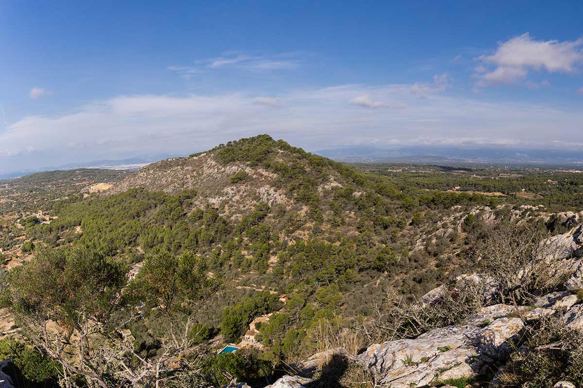
The Puig de Ses Bruixes, with an altitude of over 300 m above sea level, is that pointed mountain standing out for its curious shape, visible from much of Llucmajor.
From its summit, not only can you see Llucmajor and its surroundings—the municipality in which all the hikes in this book take place—but almost the entire island of Mallorca. It seems to challenge our intention to climb it, as we look at its triangular, rugged peak from our starting point. But we’ll soon see there’s nothing to fear, as the mountain is quite accessible from its northern slope. Moreover, an impressive panoramic view awaits!
The hike starts at Llucmajor’s cemetery, where there is a large car park. We head north, directly toward the Serra de Galdent via the Camí de Galdent. We stay on the main path, passing Camí de Buniferri on the right, until we reach Camí de Ferrutxelles (12 min), where we turn right. This is a pleasant country lane, fairly quiet, with a few houses among the trees. The silence may be broken by the occasional barking of a dog alerted by our presence. When the tarmac ends near a crossroads, we cross the Camí des Puig (our return route will come back from the left here) and continue on the Camí de Ferrutxelles, which becomes a stony track.
Walking here, we get a clear view of our destination, Puig de Ses Bruixes—“Witches’ Mountain”—and we can appreciate its strange rocky shape. From this point, its summit looks inaccessible, but as we walk around its base, its appearance changes.
At 25 min, we continue to the right (the path to the left leads to some estates at the foot of the mountain), still following Camí de Ferrutxelles, with a slight descent. Soon we reach a wide path, the Camí de Son Saleta, where we turn left. It’s interesting to note the old water channel on the right-hand side of this dirt road, which once carried water from the Randa mountains to Llucmajor, distributing it via small channels to every home. The walls were raised a few years later, but it has now fallen into disuse. We walk now towards the mountain, and we can see how its shape evolves.
The sandy path veers slightly left, and we pass a closed track on the right near an abandoned cement factory. We continue skirting the foot of the mountain slightly to the left. Meanwhile, we get fine views of the Randa hills to our right. At 40 min, a barely visible path climbs up to the left. It’s not very obvious, but can be followed, as it connects with our main ascent trail a bit higher up. In any case, it’s better to remain on the main path for a few more minutes until we find the start of the main ascent trail on the left, just in front of a water cistern.
Turning left here, we begin our climb on this trail, wide at first but quickly narrowing between heather bushes and pine trees. A little further up, the path bends to the right—this is where the less obvious path joins ours. Here we’ll notice someone has placed a stone arrow on the ground as a guide. The path now climbs more seriously, becoming steeper, and we ascend quickly. The views begin to open up, especially towards the Randa mountains. After passing through a gap in a dry-stone wall, we immediately turn left, where the path continues uphill. Along the way, we’ll see small stone cairns that guide us through the vegetation and rocks, as the path from here becomes harder to see. At this point, we’re already over 200 m in elevation.
After a steep but short climb, we follow the path to the left as it curves around some large rocks. Soon, we reach a large pile of stones just below a rock wall—this marks the beginning of the descent on our way back from the summit. But first we want to reach the peak, so we continue towards the goal by climbing over the rocky wall in front of us (it’s not difficult), and proceed walking and hopping from rock to rock (there’s some trail between them) until we finally reach the summit of this enigmatic mountain, Puig de Ses Bruixes, at 359 m above sea level (1 h 25 min).
And what a marvellous panorama awaits us!—open views in all directions, assuming good weather and visibility, of course. At our feet lies Llucmajor and its coast, with the island of Cabrera in front on a blue horizon. We’ll see the vast Bay of Palma with the big white city reflected in its waters. To the east, the hills of Felanitx and the whole southern coast, and the mountains of Randa. To the north, almost the entire Serra de Tramuntana is visible, from its southwestern tip to the Formentor peninsula. Even the great Bay of Alcudia and the distant mountains of Artà can be seen from here on clear days. We’ll certainly spend some time up here to enjoy it all—and maybe take a few photos!
Legend has it that the mountain’s name comes from the witches who lived in nearby caves. When carts passed at the foot of the mountain, the mules had great difficulty pulling them, as the witches would climb on the animals unseen, making it hard for them to move. The locals reported the matter to King Jaume I, who went to Puig de Ses Bruixes with two chaplains and an altar boy. He climbed to the summit in a carriage and planted a cross. Meanwhile, the altar boy, terrified, remained on a neighbouring hill—hence the name Puig de s’Escolà (altar boy). Since then, no witches have ever been seen again.
Our return route follows the same rocks back down to the pile of stones below the rocky wall, around five minutes from the summit. If we look carefully, we’ll see a red arrow painted on a nearby rock, indicating three paths—this is where our descent begins. With our back to the summit, we turn left between two rock walls and follow a well-marked trail. This path descends quickly through the trees, quite steep in some places with loose stones, but nothing too difficult. In just ten minutes, we’ll have completed the descent, arriving at a tarmac road where we turn left. At the end of this road, we turn left again to continue along the Camí des Puig towards Llucmajor. Upon reaching the intersection (which we crossed on the way out), we turn right to rejoin Camí de Ferrutxelles until reaching the Camí de Galdent. From there, a final left turn takes us back to Llucmajor, returning to the starting point at the cemetery car park—thus completing a 7.1 km circular route in 2 h 15 min.